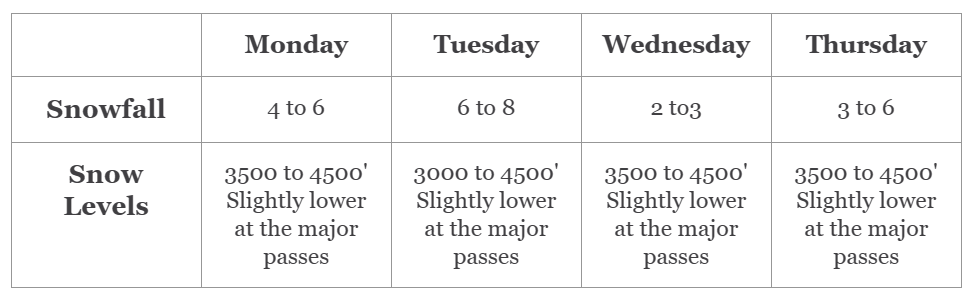
Hello skiers and snowboarders,

For much of the upcoming week, we can expect weather systems to move in from the west to bring periods of snow on and off through Thursday.


The snow levels will tend to bounce around from 3500 to 4500 feet; although lower at times for Snoqualmie and Stevens Passes. The lower slopes will be getting a wintry mix of snow mixed with rain at times. There will be better snow conditions for mid to upper mountain areas. Tuesday the snow levels briefly drop so that would make for a great day to sneak out for a ski.


The map below shows snowfall for the 24 hours ending late Tuesday with many areas getting 4 to 6 inches at 4000 feet and areas above that getting up to 8 inches. This pattern will remain in place for this coming Monday, Tuesday, and Thursday. We would greatly suggest you treat yourself to skiing over this period since the extended forecast is not favorable.


Extended Outlook

For this coming Friday and Saturday, we will briefly have snow levels increasing to 7000 feet so we can expect some moderate rainfall at times. The extended outlook for Sunday, January 28 to February 3 (map below) is in above normal temperatures.


Is there good news in the extended? YES! Many of the forecasts are showing a return to much colder temps and abundant mountain snow after February 3. We will continue to monitor this.


We will update you this coming Wednesday.

Meteorologist Michael Fagin.


The Grand Poobah of Powder is out there getting fresh tracks. Watch for Grand Poobah updates.


SUBSCRIBE HERE

Powder Alerts 2x a week. Usually Sundays and Thursdays.